Plots · Nilabadi (Neelabadi), Bandhugaon, Koraput
Fishing Pond plot
One paddy plot traced from a marked map, next to the fishing pond. This week's advice, satellite photos, greenness maps, the crop's year month by month, a weak-patch check, the nearby ponds and a soil estimate.
Summary · written 31 Oct 2026 · updated each week
Fishing Pond plot at a glance
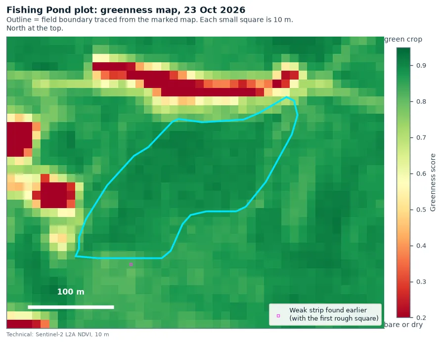
- Crop now. Greenest stage (ear forming to flowering). On the last clear satellite photo (23 Oct) the crop was still fully green (greenness 0.89 out of 1; same week last year 0.89). No sign yet of the field turning golden.
- This week. 29 Oct–4 Nov: high weather risk for blast; keep an eye on sheath blight (a weather check, not a pest count). Heavy rain expected Wed 4 Nov and Thu 5 Nov (78 mm and 91 mm). Action: open the field outlets before the rain, and look at the neck just below each ear for a grey-brown ring (neck blast). Ask KVK Koraput before any spray. Pest alerts for this plot →
- Harvest. Rough window 15 Nov – 5 Dec (estimate). It was planted about 3–4 weeks later than last year, so likely in the later part of the window. Start checking the grain from about 10 Nov; cut when 80–85% of grains are straw-coloured and hard.
- Against last year and the neighbours. In early October the crop was a little less green than last year (score 0.89; 1.00 = same). Most paddy within 2 km was a little less green than last October. Measured the same way for all fields, this plot scored 0.94 and nearby paddy typically 0.94. So against the neighbours this plot is about the same as them: it did better than about 5 in 10 of them (experimental). Much of this year's dip is the season, and the later planting.
- Weak patch. A possible weak patch of about 0.21 ha in the south-west part was less green in both years. Worth a walk to look for poor soil, standing water or pests.
- Water and a winter crop. Water already comes from the small Panchayat Pond across the road; it is the only usable source. It had 0.25 ha of open water on 23 Oct, out of a 0.81 ha outline mostly under weeds. At an assumed depth of about 1.5 m (like a swimming pool; not measured), and keeping back a quarter for the water already used (assumed), it could stretch to roughly 0.6–0.7 ha of black gram or green gram after the harvest (estimate), about a quarter of the 2.49 ha plot. Clearing some weeds is an option to get more water. The real depth still needs measuring.
- Next for the family. (1) Open the outlets before the heavy rain, then walk the south-west part and the road-side strip and check for neck blast. (2) Before December, measure the depth of the road-side Panchayat Pond with a marked pole, and decide whether to clear some weeds for more water.
Built from the satellite checks, weather forecast and estimates further down this page. Estimates and experimental checks are marked where they appear below. Trust what you see in the field first. Past weekly reports → · Where to get help (KVK, soil test, crop insurance) →
Pest alerts for this plot · 29 Oct – 4 Nov 2026 · updated 31 Oct 2026
Pest and disease alerts for this plot
Crop stage: greenest stage (ear forming to flowering), from the satellite greenness. Heavy rain expected: Wed 04 Nov (78 mm), Thu 05 Nov (91 mm). Drier days: 10 Nov–13 Nov (4 days). Low = few weather signs. Watch = several signs, look in the field. High = most signs: walk the field this week and look closely.
Untested
Built from published weather rules, not yet checked against pest counts in Koraput. Not a forecast to act on alone; ask KVK Koraput before spraying.
Blast
High
4 of 4 weather signs seen (this week): nights 22-28 °C, 5+ days with leaves wet over 10 hours, long very humid spells (60+ hours above 95%), cloudy or drizzly week.
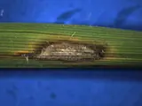
Look for: eye-shaped spots with grey centres on the leaves, and a grey-brown ring at the neck just below the ear (neck blast).
 How to spot it →
Sheath blight
Watch
2 of 3 weather signs seen (this week): very humid (120+ hours above 85%), rain on 4+ days.
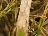
Look for: oval grey-green patches with brown edges low on the stems, near the water line.
 How to spot it →
Yellow stem borer
Low
1 of 5 weather signs seen (previous week): 6-9 sunshine hours a day.
 How to spot it →

Brown planthopper (BPH)
Low
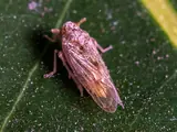
2 of 5 weather signs seen (previous week): average temperature 22-28 °C, average humidity 60-80%.
 How to spot it →
Bacterial leaf blight (BLB)
Low
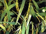
2 of 4 weather signs seen (this week): heavy rain (a 64 mm+ day or 100 mm+ week), humid (average above 70%).
 How to spot it →
Gall midge
Not a risk now
Crop stage is 'greenest stage (ear forming to flowering)': gall midge only harms the crop before the ear forms.
photo comingHow to spot it →Coming weeks
- 5 Nov – 11 Nov 2026 (forecast): Watch Sheath blight. Crop stage: grain filling / ripening.
- 12 Nov – 15 Nov 2026 (forecast): nothing above low. Crop stage: grain filling / ripening.
These use the weather forecast, so they will change.
Not sure what you are seeing?
Compare with the photos in Spot the pest. Not sure? Take a photo to the KVK: KVK Koraput contacts.
This week's advice is in the next section. The village-wide picture is on Nilabadi pest alerts.
Weekly advice · written 31 Oct 2026
This week: 29 Oct – 4 Nov 2026
Crop stage: greenest stage (ear forming to flowering). High weather risk: Blast; Watch: Sheath blight. See the pest alerts for this plot for the reasons.
What to do this week
- Harvest: not yet. The last clear satellite picture (23 Oct) still showed a green crop (greenness 0.89). Rough harvest window 15 Nov–05 Dec (estimate from last year plus radar planting dates; planted about 3–4 weeks later than last year (radar), so likely in the later part of the window). Start checking ears from about 10 Nov: harvest when 80–85% of grains are straw-coloured and hard.
- Rain: heavy-rain days expected Wed 04 Nov (78 mm), Thu 05 Nov (91 mm). Before them, open the field outlets so low corners drain; do not cut, thresh or dry grain outdoors on rainy days (IMD advice).
- Road-side strip: the plot has the Panchayat Pond just across the road on its north side. After the heavy rain, walk the strip next to the road and check it drains; standing water there can delay cutting.
- Storms/wind: if plants fall over, tie 4–5 hills together so ears stay off the water (IMD advice).
- Drier days in the forecast (under 2 mm rain a day), useful for field work: 10 Nov–13 Nov (4 days).
- Check for Blast (HIGH weather risk): Walk the field and look at the neck just below the ear: a grey-brown ring there (neck blast) makes the ear go white and empty. Also look for eye-shaped spots with grey centres on leaves. If you find it, ask KVK Koraput or the agriculture officer what to do before buying any spray.
- Keep an eye on Sheath blight (watch): Part the plants and look at the stems near the water line for grey-green oval patches with brown edges.
- After harvest: dry grain in the sun to about 14% moisture before storing; 12% if keeping it as seed (NRRI advice).
Weather is a computer forecast (estimate). Pest levels come from the weather, not from insect counts. FarmBot gives no pesticide doses: ask KVK Koraput or the agriculture officer before any spraying.
Official advice to read next:
Where
The exact plot
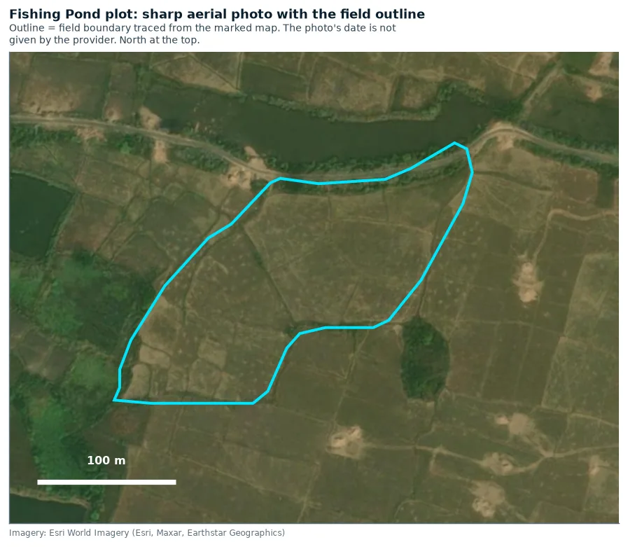
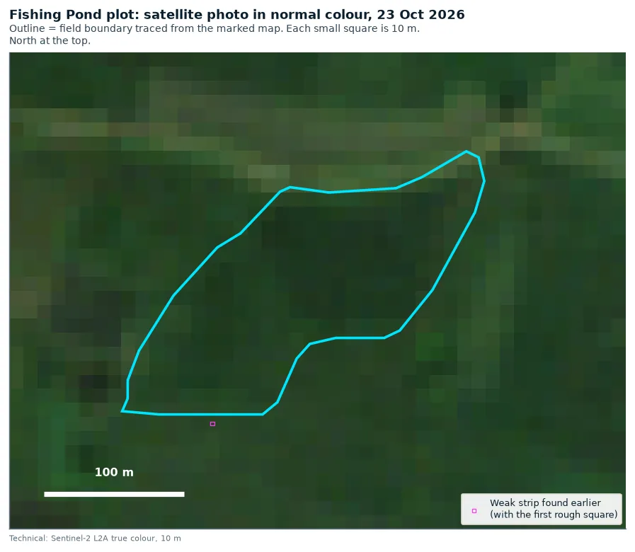
Traced from the map screenshot you marked. Each screenshot was fitted onto close-up aerial photos by matching roads, ponds and tree clumps, to within about 0.6 m (how this works). Only 10 m squares whose centre is inside the outline count towards the crop numbers.
| Plot | Centre (map position) | Size | Number of 10 m squares | How sure we are |
|---|---|---|---|---|
| Fishing Pond plot | 18.950 N, 83.267 E | 2.49 ha 6.15 acres | 249 (211 fully inside) | Position: sure. Edges: fairly sure. Traced from your close-up marked screenshot, which fitted the aerial photo to about 0.6 m. Tracing the wide screenshot instead gives about 4% less area. |
Crop health · greenness inside the outline
The crop's year, month by month
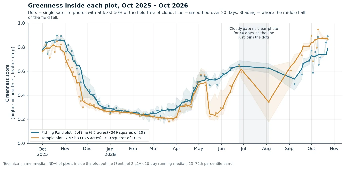
Built from 106 cloud-free satellite photos (at least 60% of the squares inside the outline were clear of cloud). The labels say what the greenness shows. They are not records of work done in the field. Seen by satellite Technical name: NDVI and phenology
25
25
25
26
26
26
26
26
26
26
26
26
26
How to read this: each box is one month, from October 2025 to October 2026. Its colour shows what the field mostly looked like from space that month.
| 2025 monsoon crop at its greenest (smoothed) | 0.86 on about 18 Oct 2025 |
| Ripening started: greenness fell below 0.7 | 12 Nov 2025 |
| Mostly harvested: greenness fell below 0.5 | 27 Nov 2025 |
| Lowest point in the dry season (smoothed) | 0.24 on about 20 Feb 2026 |
| 2026 planting (radar estimate, ±12 days) | mid-to-late August 2026 (flooded about 24 Aug) |
| September 2026, middle value | 0.62 |
| Latest cloud-free photos | 18 Oct: 0.74, 21 Oct: 0.84, 23 Oct: 0.89 |
| Greenest in 2025 · greenest so far in 2026 (smoothed) | 0.86 · 0.79 |
In 2025 the plot was greenest at 0.86, around 18 Oct. It was mostly harvested by 27 Nov. In 2026 it turned green later than the Temple plot. In September its middle greenness was 0.62, against 0.73 for the Temple plot. It was still getting greener on 23 Oct.
Planted mid-to-late August 2026 (radar estimate). Radar shows the plot flooded for transplanting around 24 Aug 2026 (±12 days), against 29 Jul in 2025. The green seen from late April into June 2026 (greenness about 0.5–0.64) came before that, so it was most likely grass or weeds, not this year's crop. Please confirm the real transplanting date on the ground.
Inside the plot · 10 m squares
Is any part of the plot always weaker? Experimental
Each 10 m square fully inside the outline (leaving out the edge row) is compared with the plot's middle value on the same day. This uses the cloud-free photos of 1–23 October, in both 2025 and 2026. A real weak patch would be low in both years.
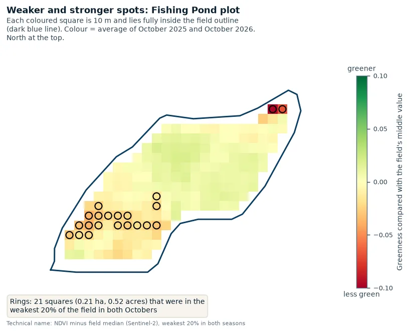
Result: a possible weak patch
188 squares tested. 21 squares (about 0.21 ha) were in the lowest 20% in both years. That is 11% of the squares, against about 4% you'd expect by chance. Most are in the south-west part of the plot. Year-to-year match score: 0.34, a weak but real pattern.
Worth a walk to look for poor soil, standing water or pests in that part. The weak strip in the old snapshot is outside this plot (about 195 m away, none of it inside), so it says nothing about it. Technical name: weak-zone check with Spearman rank correlation
Water near the plot · seen by satellite
The two water bodies next to the plot
The Panchayat Pond is just across the road to the north. It belongs to the local Panchayat, and water is already drawn from it for the plot. It is the only water source FarmBot counts for a winter crop. FarmBot tracks its open water on every cloud-free photo from 1 Oct 2025 to 23 Oct 2026. Seen by satellite
The village fishing pond is about 320 m to the south-west. Its water can't be used for the plot, so it is shown for context only and its water is not tracked.
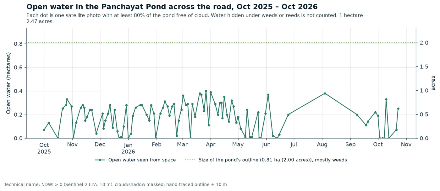
The Panchayat Pond
- Small and weedy. Open water 0.25 ha on 23 Oct, at most 0.40 ha in the last year, out of a 0.81 ha outline. The rest seems covered by weeds or reeds. Clearing some weeds is an option to get more usable water.
- Depth not measured. The winter-crop estimate assumes about 1.5 m (winter crop water).
Open water seen from space; water under floating weeds or reeds is not counted. 10 m squares, so a narrow pond is undercounted at its edges.
What the water nearby means for the crop
- Pest risk. Standing water nearby can raise the risk of planthoppers and some diseases. Look at the road-side strip when you walk the plot.
- Some extra risk of waterlogging on the road side in heavy rain. But the radar does not show that strip staying wetter than the rest of the plot (radar check).
- Slightly more humid air near the water is likely, which suits some leaf diseases. This is not measured on the plot.
Soil · from a world soil map
What the soil is probably like Estimate
A slightly sour (acidic) loam (a mixed, easy-to-work soil) on top, with heavier clay-loam below, with pH 6.2–6.4. (pH 7 is neutral; lower is more sour.) The values are read at one point inside the plot. They come from a world soil map that predicts soil on 250 m squares, much bigger than the fields. Get a Soil Health Card or a lab test before deciding on fertiliser. Technical name: ISRIC SoilGrids 2.0
| What | Top 5 cm | 5–15 cm deep | 15–30 cm deep |
|---|---|---|---|
| Clay (%; sticky, fine particles) | 25.5 | 28.8 | 32.2 |
| Sand (%; gritty, coarse particles) | 39.7 | 37.3 | 34.9 |
| Silt (%; smooth, middle-sized particles) | 34.8 | 33.9 | 32.8 |
| Sourness (pH) (scale 0–14; below 7 is slightly sour, or acidic) | 6.2 | 6.2 | 6.4 |
| Organic matter (carbon) (grams per kg; from rotted plants; more is better) | 26.4 | 15.2 | 10.9 |
| Total nitrogen (grams per kg; a main plant food) | 1.83 | 1.4 | 0.96 |
| Nutrient-holding power (a lab unit, cmol(c)/kg; technical name: CEC) | 17.3 | 16.0 | 15.0 |
| How tightly packed (grams per cm³; technical name: bulk density) | 1.31 | 1.33 | 1.36 |
Please read with care
- FarmBot is an experiment. For now it uses satellites only. Always trust what you see in the field first.
- The field outlines are traced by hand, not surveyed. They were drawn from the maps you marked and lined up with close-up aerial photos (to within about 1–2 m). The edges are right to about 5–10 m.
- The photos are coarse. Each 10 m square is one dot of colour. The Fishing Pond plot holds only about 250 of these squares, and the ones on its edge mix in bunds and the next field. So detail inside a plot is only a rough hint.
- Clouds hide the monsoon. In July and August there were only one or two cloud-free photos. A radar satellite that sees through cloud now gives rough planting dates, good to about ±12 days.
- Soil and weather numbers are computer estimates, not measurements on these fields. Areas are approximate.